Here's our friendly sun again, showcasing the extremely scenic Alaska Highway as we near the Rocky Mountains.


At Liard Hotsprings we stayed in a lovely rustic Provincial Park, featuring a natural hotsprings. Rub-a-dub-dub . . . . .

Along the highway near Summit Pass we saw some Stone sheep - this one was particularly photogenic!


Bob and Mark had a special Father's Day breakfast at the West End Saloon in Fort Nelson.


We drove through the Northern Rocky Mountains with dramatic skies highlighting the beauty of the mountains.


Our park in Watson Lake wasn't especially great, but it had a fabulous view of little Wey Lake, serene and quiet in the evening (remember, the sun doesn't go down til nearly 11 pm!).

At Watson Lake we entered Yukon Territory, where we'll be for several days until we enter Alaska on the Top of the World Highway. The highway here in the Yukon is beginning to be a bit bumpier than in British Columbia, but every bit as scenic. This bridge over the Teslin River is one of the longest in Canada. The Teslin flows into the mighty Yukon River just a bit further down from this picture. We have now passed over the Continental Divide, so the rivers flow west.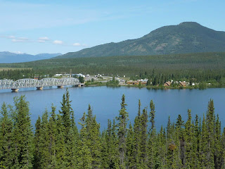

At Watson Lake we entered Yukon Territory, where we'll be for several days until we enter Alaska on the Top of the World Highway. The highway here in the Yukon is beginning to be a bit bumpier than in British Columbia, but every bit as scenic. This bridge over the Teslin River is one of the longest in Canada. The Teslin flows into the mighty Yukon River just a bit further down from this picture. We have now passed over the Continental Divide, so the rivers flow west.

We stopped at Teslin Lake for a mid-morning break of coffee and excellent rhubarb pie, and had a chance to admire the lake for a few minutes before the mosquitoes found us!


One of the fun things about this trip is the quest for the best cinnamon roll on the Alaska Highway - so far the unanimous favorite is the Braeburn Lodge between Whitehorse, Yukon Territory, and Dawson City. Yummy, and huge too!!

About 100 miles from Teslin Lake we came to the majestic Yukon River, flowing over 2000 miles through Yukon Territory and Alaska into the Bering Sea. From Teslin Lake you can get in a boat and go down the Teslin River into the Yukon River, and from there all the way to the Bering Sea!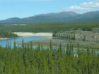

About 100 miles from Teslin Lake we came to the majestic Yukon River, flowing over 2000 miles through Yukon Territory and Alaska into the Bering Sea. From Teslin Lake you can get in a boat and go down the Teslin River into the Yukon River, and from there all the way to the Bering Sea!

Roadcat Moshi is a big help. Here she's navigating with the help of the Mileposts book and a good map.

Oops!!! Sometimes she's been known to fall asleep on duty . . . . .the little darling . . . . 
Kibo, on the other hand, is not even pretending to navigate, even though he's in the navigator's chair!!

Oops!!! Sometimes she's been known to fall asleep on duty . . . . .the little darling . . . .

Kibo, on the other hand, is not even pretending to navigate, even though he's in the navigator's chair!!
We're heading into a big booming thunderstorm as we head to the town of Mayo on the Silver Trail between Whitehorse and Dawson City. It's hard to see in the picture, but there are wildflowers along both sides of the road.


Between Mayo and Dawson City we followed the crystal clear Klondike River. At Dawson City it joins with the Yukon River, which is very silty here from glaciers in the mountains.


We took a tour, sort of , on the Yukon River in Dawson City - a small, very basic wood boat with an outboard motor, owned by a First Nation's (as Canada charmingly calls their native Canadians) gentleman named Tommy Taylor. A young woman who works for him was our guide - just the four of us and one other person in the boat - and we got to go to see Tommy's fish camp in the picture below. Also we went into the house on the shores of the Yukon River where he lives in the winter (no bathroom, just an outhouse . . . at -40 degrees!!), and met his sled dogs that he keeps on his island in the middle of the Yukon River. Very interesting, and great to be out on the water on this fabled river.


Midnight Dome mountain has a panoramic view of the Yukon River and Dawson City below. We drove the motorhome up it on a paved road, about 4.5 miles to the top. Then the next day Penny and I decided to hike up it for some much-needed exercise. Quite a workout! But the view is fantastic, and well worth it . .. .


We camped at a rustic campground at 5 Mile Lake, enjoyed the storm, and also the clearing afterwards. In this picture you can see the late evening sun on 5 Mile Lake, but you can't see the ubiquitous mosquitoes!!! In spite of the little blighters we braved a hike part way around the lake in the evening, all covered up with hoods and bandanas . . . . .

Sometimes both Kibo and Moshi help out at once, standing guard and making sure we're going the right way . . . . and looking for bugs . . .

Between Mayo and Dawson City we followed the crystal clear Klondike River. At Dawson City it joins with the Yukon River, which is very silty here from glaciers in the mountains.

Dawson City is one of our favorite places so far. It's small, only 1800 year-round residents, and has many carefully preserved historic buildings left over from the Klondike Gold Rush in the late 1800's. On June 20 it has 20.9 hours of daylight, and on December 21 it has 3.9 hours of daylight! In the winter it's -40 degrees F., and can get to the 90's in the summer, although we haven't had anything close to that.

We took a tour, sort of , on the Yukon River in Dawson City - a small, very basic wood boat with an outboard motor, owned by a First Nation's (as Canada charmingly calls their native Canadians) gentleman named Tommy Taylor. A young woman who works for him was our guide - just the four of us and one other person in the boat - and we got to go to see Tommy's fish camp in the picture below. Also we went into the house on the shores of the Yukon River where he lives in the winter (no bathroom, just an outhouse . . . at -40 degrees!!), and met his sled dogs that he keeps on his island in the middle of the Yukon River. Very interesting, and great to be out on the water on this fabled river.

These pictures were taken from the boat of Dawson City from the Yukon River.


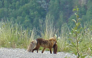
Wildlife has been somewhat scarce for the last few days, but up on Midnight Dome mountain just outside of Dawson City we saw this little fox with some poor unfortunate small animal that he apparently caught and intended to eat for dinner . . .

Midnight Dome mountain has a panoramic view of the Yukon River and Dawson City below. We drove the motorhome up it on a paved road, about 4.5 miles to the top. Then the next day Penny and I decided to hike up it for some much-needed exercise. Quite a workout! But the view is fantastic, and well worth it . .. .

On a walk up the Bonanza Creek road we saw this busy beaver braving a rainstorm to fetch branches for his lodge. Bonanza Creek is where the gold was found that started the famed Klondike Gold Rush in the late 1800s. People (mostly men, but not all) came from all over the world to try to strike it rich - this little town of 1800 people had 40,000 inhabitants in 1898, but by the 1960's was down to a mere 400 hardy souls. The Canadian government decided it was so historic it needed to be preserved and supported, so they bought up quite a few of the old buildings and made them available for public viewing. At this point, with the price of gold what it is (over $1,000 per ounce), mining is again going full swing here in Dawson. I met one lady in the laundromat who mines for gold with her husband three hours into the bush. They own two bulldozers and various other equipment, and make enough money in the four summer months to travel all over the world in the winters! Maybe we're missing the proverbial boat . . . .??? Gold mining, anyone??